| [ ASCILITE ]
[ 2004 Proceedings Contents ] |
As part of the teaching programme within a first year university unit on the earth's physical systems, a 'virtual reality' field trip has been developed to support field studies relating to geological materials and landscape history. This module aims to increase student understanding of the use of geological features in the evaluation of geological / landscape history. The module has various applications in the curriculum. For students attending a weekend excursion, the module is available as an adjunct to actual field studies and can be used by students as either a digital pre-lab or as an excursion review tutorial. For students not attending a weekend excursion (i.e. off campus students), it is used as a digital 'virtual reality' substitute for field site inspection. The module has simple linked interactive and dynamic image base digital media that provide a framework in which the geology and landscape history of excursion sites can be explored. This module is delivered as a website via CD, but can also be integrated with the 'online interface' for this unit via a QuickTime reference movie loaded inside a relevant 'Deakin (University) Studies Online' web page. The latter strategy enables assimilation of large multimedia files into online teaching formats.
The overall educational objectives for this practical component of the unit is for students to (1) develop basic skills in the identification of common geological materials (minerals and rocks), (2) gain baseline proficiencies in the reading of topographic and geological maps and (3) advance their appreciation of the linkage between field geological features and landscape history. This training is aimed at providing environmental science graduates with a simple practical geoscientific knowledge base applicable to the general evaluation of environmental problems with an earth science aspect.
The field geology teaching programme includes (1) exercises undertaken in the field during a weekend excursion and (2) a CD 'virtual reality' (VR) multimedia field tour of excursion sites and their geological and landscape features (distributed with practical manual / student guide). The geological sites visited on the actual and virtual reality excursion include folded and faulted Ordovician sandstones and mudstones originally formed in deep marine environments, Permian tillites formed by ancient glaciers and Pliocene volcanoes that are still visible as topographic highs (hills) on the landscape.
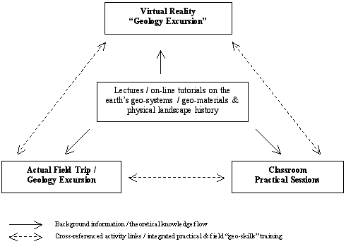
Figure 1: Interrelationship between teaching strategies for the geology
component of a first year Deakin University unit on 'The Physical Environment'
In addition, 'natural history' subjects typically possess image rich teaching resources. High resolution interactive digital resources for these subjects can involve multimedia that are not easily deliverable online to student populations in all circumstances, because of the varying quality of computer related technologies accessible to student end users (particularly off campus students). It is perhaps no coincidence that some of the many successful online subjects / courses principally involve either text or number oriented online communications with an absence of extensive, computer memory intense, interactive visual media. As a consequence, the digital 'Virtual Reality' field - based teaching materials discussed here were developed using integrated 'QuickTime® Virtual Reality' (QTVR) software delivered as a website on CD. It can be merged with the 'online interface' for this unit via a QuickTime reference movie loaded inside a relevant 'Deakin (University) Studies Online' web page. The latter approach thus facilitates the integration of large digital multimedia files into online teaching formats.
For the Virtual Reality Geology Excursion outlined here a modified development model was adopted. Individual nodes (panoramas) were linked via html pages, precluding the need to load all nodes at once when operating this multimedia module. This meant that smaller file sizes were used in the operation of this module facilitating increased viewing speeds and general ease of use.
There were a number of innovative developments undertaken for the VR movies themselves. Not all movies were 360° (or less) images assembled as a cylinder centred on a single point of observation. One movie of a linear rock face (see Feature 2 in Figure 2) was constructed as a flat linear image ('pseudo' panorama) with operation of the movie simulating a walk along the rock face. Another movie of the three dimension relationship between two particular rock structures (see Features 6 & 7 in Figure 2) was constructed as a rotatable object ('pseudo navigable object movie') with operation of the movie simulating a 'walk around' of the rock exposure exhibiting these particular structures.
With respect to the overall appearance of this multimedia module all of the screen 'pages' were designed to have a near identical look. The reason for this design specification was that since this multimedia module had a relatively high level of interactivity, consistency of interface facilitated student learning of the operational environment. Relatively little explanatory text was incorporated into this multimedia module in order to facilitate flexible application within the curriculum.
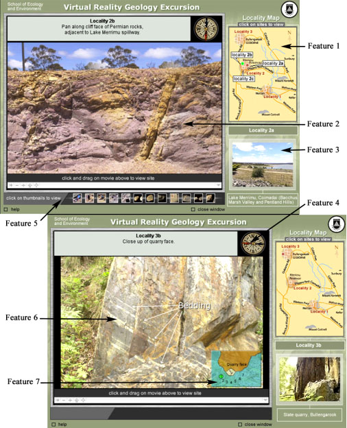
Figure 2: Two screen grabs from the virtual reality geology excursion
Feature 1 = Interactive locality diagram. Feature 2 = flat linear VR movie ('pseudo-pano.'). Feature 3 = roll over images of site locations triggered via locality diagram interactivity. Feature 4 = Interactive compass (directional) readings of landscape view seem on computer screen - triggered by operation of VR movies. Feature 5 = Thumbnails of different rock types found at each location, which when clicked on, open as a pop up window containing a close up of the rock specimen selected. Feature 6 = 'walk around' VR movie ('pseudo navigable object movie'). Feature 7 = Interactive graphic linked to feature 6 - its purpose is to facilitate visualisation of 'walk around' perspective.
The field site VR movies each contain HOTspots that contain links to web pages. They also have other attributes that run Javascript on mouse roll overs. In this multimedia module the HOTspots are visible but they can be hidden if desired by the user.
The VR movies were initially created with RoundAbout Logic software 'Nodester' (no longer produced). The movies were subsequently compiled and coded in TotallyHip's 'LiveStage Professional'. 'LiveStage Professional', is a Quicktime editing tool that utilises a timeline structure to manage movies, construct multiple tracks and code movies for interactivity.
Of note, Laurilland (1993) has commented that the use of digital resources [such as this Virtual Reality Geology Excursion] may provide students with far more sophisticated materials for doing their own analysis [i.e. answering excursion questions] than has been previously made available to them in the course of their university studies. In circumstances such as this, students may require special instruction in analytical methods related to the use of these digital resources, and to the context of their application, to effectively meet intended learning objectives. This viewpoint is borne out by the varying levels of success re student usage of the Virtual Reality Geology Excursion (see discussion below).
Of the 148 (2003) students who participated in the 'real' field excursion component of the unit, 34 student responses to a written questionnaire on the effectiveness of the CD resource were received. In general, responses can be categorised broadly on the basis of the type of usage by students of this Virtual Excursion Geology Excursion.
Yes it was fantastic. It gave me a great knowledge and grasp of the areas we would be visiting. It also helped greatly in answering questions.[Virtual] excursion sites gave [me] an idea of what we would be covering and what to expect. Complimented the lectures, pracs and excursion well.
Yes indeed, it was good to get an overview prior to attending [the excursion].
Yes, I think it helped touch [on] the subject before being thrown straight in.
Yes, it was easier to complete the set tasks at the different sites because of knowing what the site looked like.
Yes, it assisted me because I knew what to expect and I understood what [the demonstrator] was explaining better.
Computer programme gave me a good idea of [the] geology of the sites before [the] excursion.
Yes it did. I could focus on details [as] I had background knowledge ... helped [in that I knew] what I was looking for.
Excursion sites gave [me an] idea of what we would be covering and what to expect. [It] complemented the lectures, pracs and excursion well.
Despite the above comments, and even though there are detailed introductory explanations given for each excursion site in the excursion handout (and symbols that link handout content to the CD), relatively few students were able to, or attempted to generate preliminary answers to excursion questions using the Virtual Reality Geology Excursion CD (based on verbal feedback from students). This may be partly a consequence of students requiring demonstrator instruction and discussion, which is provided on the actual field trip, to confidently answer the relevant excursion questions. It might therefore be concluded that, without the provision of a better method for contextualising excursion site 'visuals' on the Virtual Reality Geology Excursion, this multimedia module in its current form is of limited use as an excursion pre-lab. As previously noted, the field visualisations of the Virtual Reality Geology Excursion are intended to provide frameworks in which students can build an appreciation of the linkage between geological features and landscape history. The problematic value of the Virtual Reality Geology Excursion as a pre-lab may relate to students having difficulty in making conceptual links between geological theory (considered in classroom studies), and related virtual field views of geological features. This problem may be overcome in the future by the insertion of audio or video clips of demonstrator field instruction, into the multimedia module, and / or by the integration of pertinent readings assignments designed to prime student understanding of relevant field geological features (see further discussion below). As a rider to the above conclusions, it is worthy of note that there may also be an issue with student motivation given that no assessment imperative exists for students to undertake this pre-lab exercise, if they attend the actual excursion.
Yes definitely, you pick up things on the computer that you may miss at the actual site. [It was] very helpful.Yes, being able to look at particular [sites] as it was hard to complete on the excursion with so many people [in attendance].
Yes, I thought the third site was great [in] assisting my visualisation because it looked exactly like the actual location.
It was ... helpful to go back and visit the sites after the excursion.
Yes, [it] helped fill in gaps that we may have missed while on actual excursion.
... and I [could] review these sites after excursion.
For students who attended the actual excursion, a significantly appreciated aspect of this multimedia module was the ability to visually 'revisit' excursion sites after the actual field trip during the preparation of their excursion report for submission.
Yes, the Virtual Excursion was very useful. It helped me better understand certain aspects of the reading material. It was just as good as being there.Yes, especially seeing [real examples] as a lot of the material [in textbooks etc is] hard to visualise.
Yes, visually seeing the materials and features helped [me] to recognise and name specific rocks .... in real life situations.
Students who utilised the Virtual Geology Reality Excursion as a standalone experience of excursion field sites generally presented reports of a consistently high quality. This perhaps reflects a relatively deep level of understanding of field site geology facilitated by related 'forerunner' reading assignments, which seem to have had the effect of appropriately contextualising the field geology visuals of this multimedia module. It appears that the reading assignments used in this way are useful tools for priming student understanding of field geological features presented in the Virtual Reality Geology Excursion. The converse is also probably true, as suggested by student questionnaire responses, which indicate that the visualisations in the virtual excursion enhanced their understanding of textbook presented explanations of geological features and processes. Typically, students undertaking this mode of field studies approached unit teachers for further verbal explanations pertaining to the preparation of their field report submission. This latter teacher input may be substituted in the future by the additional insertion of audio or video clips of demonstrator field instruction, into the multimedia module.
I think the visual aspect of learning about earth processes and features is very important to [the] .... understanding [of] such large scale concepts.
A total of 30 students (out of the same group of 34 students) responded that they would like to see more of this type of computer assisted learning (virtual reality excursions) to support field studies. However, based on verbal feedback, it is worthy of note that 'real' field excursions remain a well appreciated learning experience by students undertaking geoscientific study programmes.
Comer, S.D. (1999). Immersive Imaging Technology: VR for the Web in Academia. Syllabus99 Conference Proceedings [viewed 26 May 2004] http://comers.citadel.edu/talks/syllabus99/scomer.htm
Driver, R. and Bell, B. (1986). Students' thinking and the learning of science: A constructivist view. School Science Review, 64(240), 443-456.
Gulie, S.W. (2000). QuickTime for the Web: A Hand-on Guide for Webmasters, Site Designers and HTML Authors (with CD-ROM). Morgan Kaufmann Publishers, San Francisco.
Honebein, P.C., Duffy, T.M. and Fishman, B.J. (1991). Constructivism and the design of learning environments: Context and authentic activities for learning. In T. M. Duffy, J. Lowyck and D. H. Jonassen (Eds), Designing environments for constructivist learning, Berlin: Springer-Verlag, 87-108.
Laurillard, D. (1993). Rethinking University Teaching: A framework for the effective use of educational technology. Routledge, London and New York.
Merguerian, C.M., Bennington, J.B., Boccabbella, F., Chlystun, R. and Ullrich, K. (2002). QuickTime Virtual Reality: A versatile tool for presenting field trips, specimens and microscopy in lectures and on the web. Geological Society of America: 2002 Denver Annual Meeting Abstracts, Paper No. 85-28 [viewed 2 June 2004]. http://gsa.confex.com/gsa/2002AM/finalprogram/abstract_43432.htm
Neo, K.T.K. (2003). Using multimedia in a constructivist learning environment in the Malaysian classroom. Australian Journal of Educational Technology, 19(3), 293-310. http://www.ascilite.org.au/ajet/ajet19/neo.html
Neo, K.T.K. and Neo, M. (2001). A constructivist learning experience: Reconstructing a web site using web based multimedia authoring tools. Australian Journal of Educational Technology, 17(3), 330-350. http://www.ascilite.org.au/ajet/ajet17/neo.html
Pereira, D. and Brilha, J.B.R. (2000). Virtual field trip in the Mirandela region (NE Portugal) - an example of how to enhance Geosciences education. I Seminário sobre Utilizacão das Tecnologias da Informacão em Geologia Universidade do Minho, Braga, 3-4 de Fevereiro de 2000. Ciências da Terra, 2000, volume especial IV [viewed 2 June 2004] http://www.geopor.pt/geotic/papers/pereira.html
Schafe, L.M. and Clarke, R. (1997). Tertiary educational uses of partially immersive virtual reality. Proceedings ASCILITE'97 Conference, Perth [viewed 26 May 2004] http://www.ascilite.org.au/conferences/perth97/papers/Schafe/Schafe.html
Warne, M.T. and McNaught, C. (1995). Evolution of a first year university multimedia module on palaeontology. In J. Pearce, A. Ellis, C. McNaught & G. Hart (Eds), Learning with Technology: Proceedings ASCILITE'95 Conference. University of Melbourne, Melbourne, 529-534.
Warne, M.T., Gleadow, A. and Price, R. (1996). Virtual Reality Geology: Extending Field Studies into the Computer Classroom [CUTSD Project Application, May, 1996 (for 1997)] La Trobe University, Melbourne, Australia.
| Authors: Mark Warne, School of Ecology and Environment, Deakin University (Burwood Campus); 221 Burwood Highway, Burwood, Victoria, Australia, 3125. mwarne@deakin.edu.au David Owies, Learning Services, Deakin University (Burwood Campus); 221 Burwood Highway, Burwood, Victoria, Australia, 3125. daveo@deakin.edu.au Glenn McNolty, Learning Services, Deakin University (Geelong Waterfront Campus); 1 Gheringhap Street, Geelong, Victoria, Australia, 3217. glennmc@deakin.edu.au Please cite as: Warne, M., Owies, D. & McNolty, G. (2004). Exploration of a first year university multimedia module on field geology. In R. Atkinson, C. McBeath, D. Jonas-Dwyer & R. Phillips (Eds), Beyond the comfort zone: Proceedings of the 21st ASCILITE Conference (pp. 924-933). Perth, 5-8 December. http://www.ascilite.org.au/conferences/perth04/procs/warne.html |
© 2004 Mark Warne, David Owies & Glenn McNolty
The authors assign to ASCILITE and educational non-profit institutions a non-exclusive licence to use this document for personal use and in courses of instruction provided that the article is used in full and this copyright statement is reproduced. The authors also grant a non-exclusive licence to ASCILITE to publish this document on the ASCILITE web site (including any mirror or archival sites that may be developed) and in printed form within the ASCILITE 2004 Conference Proceedings. Any other usage is prohibited without the express permission of the authors.